Types of Clouds
(and what they tell us)
Clouds are the visible signposts of weather. As air is warmed, it expands and thus can hold a great deal of moisture. As it rises, it cools and the moisture it can hold is reduced. The moisture condenses causing what we see as clouds. By looking at the characteristics of clouds, we can understand what is happening and what may be happening in the near future.
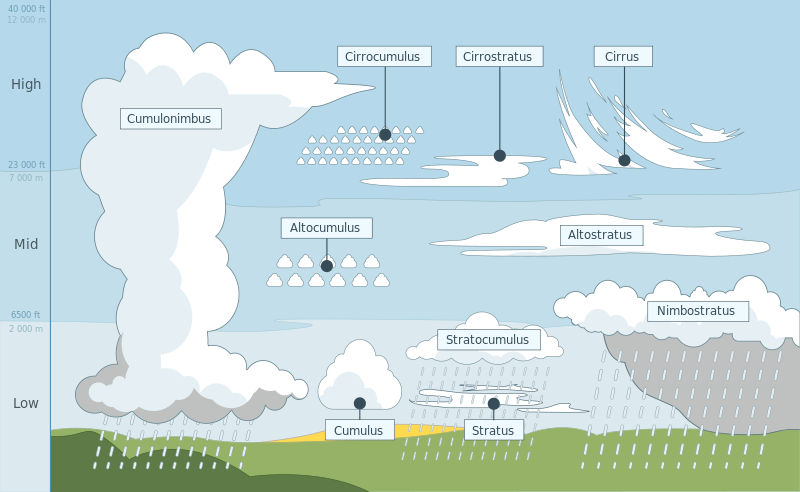
Although cloud shapes can seem infinite, in fact, they have been grouped according to shape (2 types) and the altitudes at which they form (3 levels). The 2 basic shapes are cumululoform – the big puffy cotton ball-like shape and stratoform – the flatter, more stretched out pattern.

Cumulus clouds are created by the vertical movement of warm air trying to rise over the colder air above it. This vertical movement is therefore unstable air.
When there is warmer air above colder air, there is little vertical movement and therefore the air is stable. Clouds here don't pile up in big ball shapes but rather stretch out in broad, featureless, flat clouds called stratoform clouds.
High clouds form above 21,000 feet / 7,000 meters and have the prefix 'cirro'. They are made up of ice crystals. They are cirrus, cirrocumulus and cirrostratos.
Middle clouds form between 6,000 - 21,000 feet / 2,000-14,000 and have the prefix 'alto'. They are altocumulus and altostatus.
The lower clouds form below 6,000 feet / 2,00 meters. They are are cumulus, stratus, stratocumulus and nimbostratus.
One remaining form of cloud needs to be addressed and that is fog. Fog is simply a low-lying cloud whose base is on or very very close to the surface of the earth. There are 2 types.
Radiation fog is what we see on cool, clear nights in late spring and early fall. It is caused by the air close to the earth's surface being cooled to the point that moisture in the air is released (in other words, the temperature has fallen to the dew point). This fog can be dense or thin or patchy. It usually burns off as the sun rises in the morning.
Advection fog is created by warm air blowing over cold water. The moisture in the wind is released as the air is cooled. This can result in quite dense fog, sometimes referred to as sea fog. which does not burn off as the sun rises – after all, the air is already warmer than the water beneath it. A change of wind direction, ideally with much cooler air will disperse advection fog.
Click here to return to WEATHER
Click here to return HOME
The Complete Log Book For Cruising Sailors
written by a sailor for sailors

a practical, easy-to-use yet thorough format to record all of the necessary information about your boat and any cruises you take – whether exploring home waters or voyaging to distant ports across the Great Lakes.
.
Click here for more details